There’s something magnetic about a framed world map hanging on the wall. It’s not just décor—it’s a statement. A framed map instantly elevates a room, turning blank walls into portals of imagination. Every glance at it reminds you of journeys taken, places yet to explore, and the sheer beauty of our interconnected world. Whether you’re styling a cozy living room, a sleek office, or a classroom that sparks curiosity, a framed world map is more than decoration. It’s history, art, and adventure in one elegant piece.
Why a Framed World Map Belongs in Your Space
A map pinned to a corkboard may be functional, but framing transforms it into an heirloom-worthy display. The frame protects the edges, prevents yellowing, and keeps the design crisp for years to come. It also creates a sense of permanence—your map no longer looks like a temporary travel tool but like an intentional piece of art.
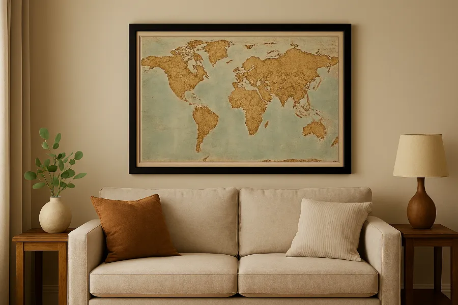
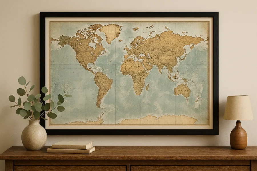
Framed world maps are versatile. They can act as the centerpiece above a fireplace, bring order and elegance to a study, or add personality to a hallway gallery wall. And unlike abstract art, a map invites conversation. Guests are drawn in, pointing out countries they’ve visited or tracing routes they dream of taking.
Styles of Framed World Maps
Classic Vintage Charm
If you’re chasing nostalgia, a vintage-style framed map is the way to go. With muted sepia tones, aged textures, and intricate cartographic details, it feels like a piece straight out of a library from centuries past. These maps pair beautifully with dark wood frames, leather-bound books, and rustic interiors.
Modern Minimalist Appeal
For sleek, contemporary spaces, black-and-white framed maps or modern artistic interpretations strike the perfect balance. These maps often use bold typography, clean lines, and crisp framing options like matte black or brushed metal. They fit effortlessly in city apartments or modern workspaces.
Statement Oversized Maps
Sometimes, size makes the difference. An oversized framed world map can command attention in a boardroom, entryway, or family room. Think of it as a mural with function—it fills the wall while sparking stories.
Farmhouse & Rustic Options
For homes with a cozy, countryside aesthetic, distressed wood frames and canvas-backed maps bring warmth. These framed maps feel personal, homey, and timeless.
Personalization That Makes It Yours
One of the best parts of choosing a framed world map today is the ability to personalize it. You can order a push pin map that lets you mark destinations with colored tacks, making it a living diary of your travels. Many sellers also offer customization—adding your family name, a favorite quote, or even creating a legend of your adventures.
Here are a few personalization ideas:
- Add pins for past and future travels.
- Customize with a family travel motto.
- Create a “bucket list” legend in the corner.
- Use different pin colors for solo vs. family trips.
This interactivity transforms your map into more than décor—it becomes a storytelling piece.
Practical Benefits Beyond Beauty
Yes, a framed world map looks stunning, but the value doesn’t stop there. Framing preserves the quality of the map, shielding it from light damage, moisture, and physical wear. High-quality maps often use archival inks and acid-free paper, ensuring the colors don’t fade. For classrooms or home offices, framed maps also offer a practical advantage—they provide clear, detailed cartography while still looking stylish.
How to Style a Framed World Map in Your Home
Living Room
Make it the centerpiece above the couch or fireplace. Pair with complementary décor like globes, travel books, or minimal shelves.
Bedroom
Opt for a softer palette—pastel or watercolor-style maps framed in white or natural wood—to create a calming effect.
Home Office
Choose a detailed, professional-looking framed world map that doubles as inspiration and a quick reference tool during work.
Kids’ Room
A colorful framed map sparks curiosity and makes geography fun. Pair it with a globe or educational posters for a complete look.
Choosing the Right Frame
The frame you choose makes or breaks the piece.
- Wood frames: Warm, classic, and versatile.
- Black frames: Sleek, modern, professional.
- Gold or brass frames: Glamorous and eye-catching.
- Distressed/rustic frames: Perfect for farmhouse or vintage-inspired interiors.
The key is harmony—match the frame with both the map’s style and your room’s aesthetic.
Gifting a Framed World Map
Few gifts balance beauty and thoughtfulness like a framed world map. It’s ideal for newlyweds planning a lifetime of travels, families who cherish shared adventures, or graduates setting off to explore. Personalized versions make the gesture even more meaningful. Imagine gifting a couple a push pin map with their honeymoon destination already marked—it’s a keepsake they’ll treasure.
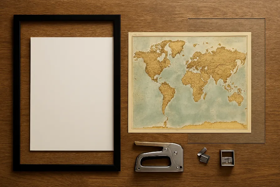
DIY Framed World Maps
If you’re crafty, you don’t need to buy one pre-framed. You can:
- Print a high-resolution world map (archival quality recommended).
- Mount it on foam board or canvas for sturdiness.
- Choose a frame that complements your décor.
- Add a protective acrylic or glass cover.
DIY gives you control over the size, style, and finishing touches. It also makes the map feel more personal.
Where to Buy Framed World Maps
From online marketplaces to specialty décor shops, options abound. Premium handcrafted versions often feature museum-quality printing and custom frames, while affordable poster-sized maps can be easily framed at home. The right choice depends on your budget, aesthetic, and how permanent you want the piece to be.
| Style | Best For | Frame Options | Price Range |
|---|---|---|---|
| Vintage | Libraries, rustic interiors | Dark wood, distressed | $$–$$$ |
| Modern | Offices, apartments | Black, metal | $$–$$$ |
| Oversized | Boardrooms, living rooms | Wide wood, custom | $$$+ |
| Rustic | Farmhouse, cozy homes | Distressed wood | $$–$$$ |
| Personalized | Gifts, family use | Custom | $$–$$$ |
Final Thoughts
A framed world map is not just a wall accessory—it’s an experience. It ties together aesthetics, education, and personal storytelling. Whether you choose a minimalist black-and-white print, a sprawling vintage map, or a custom push pin version, you’re bringing the world closer to home. It’s art with a story, a conversation starter, and in many ways, a daily reminder of the journeys that shape us.

")


